PhD - Geoscience
Princeton - 2013
Professional Preparation
MS - Geophysics
Peking University - 2008
Peking University - 2008
BS - Geology
Sun-Yat sen University - 2005
Sun-Yat sen University - 2005
Research Areas
Structure Seismology
Exploration Seismology
Earthquake Seismology
Publications
Deep Seafloor Ambient Seismic Noise Monitoring for Oceanic and Atmospheric Pressure Changes 2026 - Journal Article
Seismic Monitoring of Baseflow and Groundwater Changes in the Yellowstone National Park 2025 - Journal Article
Mapping Spatiotemporal Variations of Near‐Surface Seismic Velocity to Monitor Groundwater in Central Oklahoma 2025 - Journal Article
Viscoelastic wave propagation: spectral-element simulation with a novel GSLS-type wave equation 2025 - Journal Article
Viscoelastic wave propagation: Spectral-element simulation with a novel GSLS-type wave equation 2025 - Journal Article
Power-law frequency-dependent Q simulations in viscoacoustic media using decoupled fractional Laplacians 2024 - Journal Article
Joint Migration Inversion Based on a Full-Wavefield Acoustic Wave Equation With Vector Reflectivity 2024 - Journal Article
Awards
NSF CAREER - National Science Foundation [2021]
J. Clarence Karcher Award - Society of Explorational Geophysicists [2019]
Editors’ Citation for Excellence in Refereeing– Geophysical Research Letters - American Geophysical Union [2019]
Jackson School Distinguished Postdoctoral Fellowship - The University of Texas at Austin [2013]
Appointments
Associate Professor
The University of Texas at Dallas [2021–Present]
The University of Texas at Dallas [2021–Present]
Assistant Professor
The University of Texas at Dallas [2015–2021]
The University of Texas at Dallas [2015–2021]
Jackson School Distinguished Postdoctoral fellow
The University of Texas at Austin [2013–2015]
The University of Texas at Austin [2013–2015]
News Articles
Professor, Students Win Honors from Society of Exploration Geophysicists
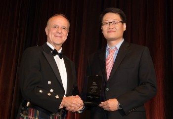 Dr. Hejun Zhu, assistant professor of geosciences, is one of two early career scientists who received the J. Clarence Karcher Award from the Society of Exploration Geophysicists (SEG) at the organization’s annual meeting in September.
Dr. Robert Stewart (left), president of the Society of Exploration Geophysicists, presents the J. Clarence Karcher Award to Dr. Hejun Zhu, assistant professor of geosciences at UT Dallas.The award recognizes significant contributions to the science and technology of exploration geophysics by individuals younger than 35.
In addition, two geosciences doctoral students, Jaewook Lee and Jidong Yang, were awarded the Anadarko/SEG Scholarship, with each receiving $10,000. In addition, doctoral student Mengli Zhang was one of 22 recipients of the Earl D. and Reba C. Griffin Memorial Scholarship.
Geoscientists Create Deeper Look at Processes Below Earth’s Surface with 3D Images
 Geoscientists at The University of Texas at Dallas recently used massive amounts of earthquake data and supercomputers to generate high-resolution, 3D images of the dynamic geological processes taking place far below the Earth’s surface.
In a study published April 29 in Nature Communications, the UT Dallas research team described how it created images of mantle flows in a subduction region under Central America and the Caribbean Sea using a computationally intensive technique called a full waveform inversion (FWI).
“This is the first comprehensive seismic study to directly image 3D mantle flow fields in actual subduction environments using advanced FWI technology,” said Dr. Hejun Zhu, corresponding author of the study and assistant professor of geosciences in the School of Natural Sciences and Mathematics. Dr. Jidong Yang, who earned his PhD in geosciences from UT Dallas in May, and Dr. Robert Stern, professor of geosciences, are the study’s co-authors.
Dr. Hejun Zhu Receives Over $500,000 From NSF
 Dr. Hejun Zhu received $536,729 from the the National Science Foundation for his research on Developing a Multi-Parameter Seismic Model of North America. Dr. Zhu and his team are developing a multi-parameter seismic model that uses state-of-the-art full waveform inversion technology and high-quality waveform records that will help geophysicists to better investigate physical properties of the Earth. This study may allow scientists to infer distributions of temperature, water content, and deformation.