Ph.D - Geography
State University of New York at Buffalo - 1994

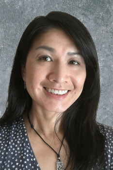
May Yuan
Fellow of AAAS, AAG, and UCGIS
Ashbel Smith Professor of Geospatial Information Sciences
Director, Geospatial Analytics and Innovative Applications Laboratory (https://gaia.utdallas.edu/)
Editor in Chief, International Journal of Geographical Information Science (https://www.tandfonline.com/toc/tgis20/current)
Professional Preparation
M.A. - Geography
State University of New York at Buffalo - 1992
State University of New York at Buffalo - 1992
B.S. - Geography
National Taiwan University - 1987
National Taiwan University - 1987
Research Areas
Her research interest expands upon space-time representation and analytics to understanding geographic dynamics. Over the years, she has been developing approaches to represent and model geographic processes and events in G.I.S. databases to support space-time query, analytics, and knowledge discovery. Her research has been supported by NSF, NASA, Department of Defense, Department of Homeland Security, Department of Justice, Department of Energy, Environmental Protection Agency, National Oceanic and Atmospheric Administration, United States Geological Survey, National Institute of Standards and Technology and state government agencies in the U.S.A. She and her students at Geospatial Analytics and Innovative Applications (GAIA) Lab explore ways to understand the dynamics of people, events, and places, the connections among brain health, spatial behaviors, and the environment, and the learning mechanisms for humans or machines to conceptualize, represent, and compute geospatial processes.Publications
Multiple representations in geospatial databases, the brain’s spatial cells, and deep learning algorithms 2024 - Journal Article
Embedding scale: new thinking of scale in machine learning and geographic representation 2022 - Journal Article
Identifying temporal patterns of multilateral spatial interactions: Using international trades as an example 2021 - Journal Article
Geographical information science for the United Nations’ 2030 agenda for sustainable development 2021 - Journal Article
Geographical Enrichment of Historical Landscapes: Spatial Integration, Geo-Narrative, Spatial Narrative, and Deep Mapping 2020 - Book Chapter
Additional Information
About Me
May Yuan received all her degrees in Geography: B.S. 1987 from National Taiwan University and M.S. 1992 and Ph.D. 1994 from State University of New York at Buffalo. She is Ashbel Smith Professor of Geospatial Information Sciences (GIS) at the University of Texas at Dallas (UT-Dallas), and a fellow of the American Association for Advancement of Science (AAAS), the American Association of Geographers (AAG), and the University Consortium for Geographical Information Science (UCGIS). Before joining UT-Dallas in August 2014, she was Brandt Professor and Edith Kinney Gaylord Presidential Professor and Director of the Center for Spatial Analysis at the University of Oklahoma (1994-2014). She assumed the Editor in Chief of the International Journal of Geographical Information Science in 2017 after eight years as the regional editor for the Americas. She serves on US NOAA Environmental Information Services Working Group (EISWG) to the NOAA Science Board (2016-2022) and served on U.S. National Geospatial Advisory Committee (NGAC) to the Federal Geographic Data Committee (2016-2021). She was the presidents of Cartography and Geographic Information Society (CaGIS: 2020-2021) and the University Consortium of Geographic Information Science (UCGIS: 2011-2012). She served as a program director at the National Science Foundation (2022-2025). Her research interest expands upon space-time representation and analytics to understand geographic dynamics. Over the years, she has been developing approaches to represent and model geographic processes and events in GIS. databases to support space-time query, analytics, and knowledge discovery. Her research has been supported by NSF, NASA, Department of Defence, Department of Homeland Security, Department of Justice, Department of Energy, Environmental Protection Agency, National Oceanic and Atmospheric Administration, United States Geological Survey, National Institute of Standards and Technology, and state government agencies in the U.S.A. She founded the Geospatial Analytics and Innovative Applications (GAIA) Lab at UT-Dallas. She and her students explore ways to capture and apply the concepts of place for space-time representation and analytics.News Articles
Geographers Association Honors Researcher
 Dr. May Yuan, Ashbel Smith Professor of geospatial information sciences (GIS) at The University of Texas at Dallas, has been named a 2021 fellow of the American Association of Geographers (AAG).